
From left Adam Jared Apt, David Govatski and Rebecca Enman
Recently I had the incredible opportunity to visit the new Wayfinding exhibit at Plymouth State University's Museum of the White Mountains with some of the curatorial team that created it. They coordinated the contributions of dozens of lenders, sponsors and supporters, all of whom are credited at the beginning of the exhibit. You can read more about the exhibit here.
We were accompanied by another historian and an interesting creative couple (one a furniture master, the other a book artisan) all with great interest and insights into maps and white mountain art and history.
For an exhibit ostensibly about maps, they have created an astonishing story, using a wide variety of objects.


(not that this has anything to do with Marcel Duchamp)
They have created a display environment of simultaneous intimacy and vastness. This was especially challenging due to the fact that much of the interior architecture reveals that the building was once a church. That however is appropriate given the obvious reverence to the both the subject and its treatment in this space.
The combination of two and three dimensional items on display is visually stunning and sculptural and the labels intellectually stimulating - even downright Shakespearean!

Bard-like romantic and philosophical aphorisms comparing maps to campfires and epic poems and so on, are spread throughout the exhibit, with none of the confusing non sequitur saccharine nonsense about rose names and nightingale songs. This is real, important stuff!

The exhibit also features a video projection of the Hitchcock Atlas of 1878.


The mysterious floating map above was created by Robert Scott by layering thin balsa wood sheets using cutouts from the Franconia quadrangle map.

Below the Scott map is the 1872 Snow and Bradlee map made of papier-mache along with it's original packaging. This was one of two published relief maps of the region from the nineteenth century.

The other, the 1879 Schedler relief map, can be found in the case along the wall (it is the larger map on the right).

Now let's move to the doorway beyond and enter the "Mountain Studio."

Here you will find a bright, bold, colorful, welcoming laboratory with hands-on activities to explore and create relief maps. It is fun for all ages!

You should not leave the exhibit without picking up a few souvenirs and signing up for the summer speaker series.
You can bring home a nice, always handy, book mark.

Front of bookmark above
Back of bookmark below

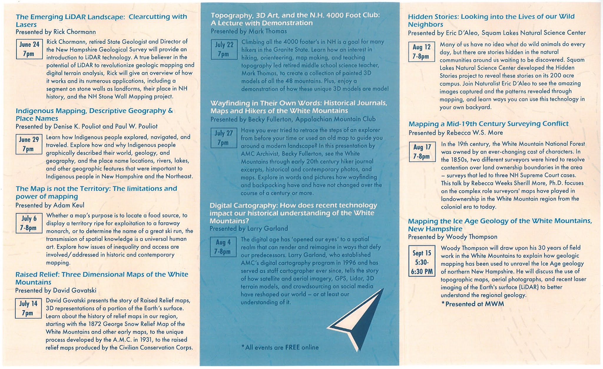
Summer Speaker Series brochure

And a fold-out catalog of sorts chock full of images and information.


While extensive in its scope, there is one type of map I would like to have seen included, namely the "vertical" maps created for rock climbers.

See our previous blog here and related video of Cathedral Ledge here for an example. This map is also featured in our cell phone history mapping program theclio in which you turn on your cell phone's location (or search for a location, title, or ) and it guides you to local history sites. The entry for Cathedral Ledge is here.

At the end of our adventure we were treated to an exceptional opportunity to see a new acquisition for one of the collector/curators, a hand-colored map showing the Portland to Ogdensburg railroad line. The railroad had many interesting connections to White Mountain art and history. For example see our previous blog here. You can read more about that railroad line here and here.
In conclusion, remember ...

Thanks for reading and please let me know what you think! For more maps visit us at the Conway Public Library's Henney History Room. We have over 400 maps in our collection!
Great review of a fabulous exhibit - so glad we were able to see it. Well worth a detour or a destination day.
ReplyDeleteThanks for this great, comprehensive, and well-informed review that tells readers what they will really see.
ReplyDelete