Recently a patron asked about this somewhat mysterious and enigmatic piece of public sculpture in the Rotary Park at the corner of Route 16/302 and Depot Road in North Conway.

Tucker's summer home in North Conway was featured in an 1892 Atlas which we have at the Conway Public Library's Henney History Room. Here is the same scene today from Google street view here.
Note the magnificent birch tree from which the summit home gained its name (more on this tree in a future blog).
The view above is as if the sun were coming from the northeast and below is as if the sun were coming from the northwest. If you compare the images, look for the meandering brooks, the field patterns, you can even see the Red Jacket's swimming pool.
Above you can see ten buildings along the road, the big house and large barn that was part of Payson Tucker's estate.
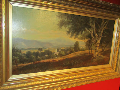
That painting is now in the collection of the Conway Historical Society and that birch tree is featured prominently.
In previous blogs we examined different versions of a single view of Mount Washington from Sunset Hill starting with an enlargement of a print at the library.
I mentioned then that the scene had been enlarged for easy study and can be found on the stair hall leading down to the Henney History Room at the Conway Public Library. The print was made from the painting below by Kensett. The painting was purchased by the American Art Union and made into an engraving by James Smillie, and distributed to 13,000 Art Union subscribers throughout the country.
You can read about that here. Perhaps some day we will be able to hear the tune at one of the area's music venues in honor of one of our early patron of the arts.
For me, this object can serve as a story gateway that leads from this monument, to a man, to a house, to maps, to lasers and finally to the mountain summits at the edge of the horizon for some of the most famous views in White Mountain Art.
For the younger crowd, the site serves as a Poke gym through the Pokemon Go mobile game (My son knew all about that subject, I on the other hand was clueless about that). See an article about that from the Conway Daily Sun here.
However, I knew just by glancing at it that for past generations, it served a more practical function as part of the necessary infrastructure during the horse and buggy days.
It is a watering trough, a once critical remnant of a lost landscape and time period that remains today only as a vague memory.
To explore the story, we will use both modern technology and also look at historic photos, maps, newspaper clippings, wills, legal documents, paintings, prints, sculpture, and even rugs and sheet music.
You can start your own search with your smart phone through the "Clio" app. The entry for this fountain is here. To look for other historic sites in the Conway area check out this link here. To use this program simply turn on your phone's location and ask Google to search for "the clio dot com" and as you drive around it will direct you to a host of historic sites.
The Google Street View image above, as well as a series of related maps and satellite images, can be found here. You can use this site to navigate to the park. It is conveniently located just south of the new home of the Mount Washington Valley Chamber of Commerce and west of a free parking lot from which to explore the area.
You can see the Chamber website here.
The 2003 Town of Conway Annual Report here reveals that this was not it's original location. It was moved here in September of that year.
The photo in the lower left corner shows Poco & Athena as the "first customers" to the fountain at its new location. (Photo by Karen Hallowell)
Also on the cover is a photo of Gary Webster, Chair of the Board of Selectmen, along with members of the North Conway Rotary Club, cutting the Ribbon at the opening ceremony for the Depot Street Park. (Photo by Lloyd Jones/Conway Daily Sun).
Coincidentally construction of the Conway Public Library's new addition also began in 2003 as evidenced by the photo of then Librarian, Margaret Marshner, standing in front of the Conway Public Library. (Photo by Tom Eastman, then of the Mountain Ear).
By moving the fountain to the new location, the trough lost it's original context and some of the story connections. We will attempt to reset that here (at least virtually). The Conway Public Library's Henney History Room has a photo of it in it's old location here.
As documented in bold capital letters on the watering trough, it was a gift to the community from Payson Tucker in 1894.
Here is a portrait of Payson Tucker (no, not the fish face above, but rather the guy with the serious handlebar mustache below, although there is a bit of a resemblance if you look closely).

Tucker was a railroad magnet, business entrepreneur, and philanthropist who had a summer home in Conway (more on that later).
According to "Find a Grave" here he was born Feb 14, 1840, died at age 60 on April 27, 1900, and is buried in Evergreen Cemetery, Portland Maine.
The Conway Historical Society has a marble bust of Payson Tucker which we believe was originally presented to the Maine Eye and Ear Infirmary by his widow after Payson's death. A fifty-six page pamphlet from the November 21, 1900 "unveiling" of the bust can be found here. Information about the sculptor, Frederick A. Shaw, can be found on p. 25 here. Shaw's name is inscribed on the back of the bust.
According to wikipedia and mainememory the Maine Eye and Ear Infirmary was founded in 1886 and merged with Maine General Hospital in 1951. See links here and here.
That same face was also profiled on a three-handled silver trophy cup with a gilt (gold) interior, made by Tiffany and Company now on display at the Portland Museum of Art here (click on images to enlarge them).
Another side of the cup celebrates Tucker's involvement with Union Station in Portland Maine.
The inscription can be seen at this link here.
It reads "Presented to Payson Tucker by employe's (sic) of the Maine Central Railroad - a testimonial of affection and x?" can't read the last word. December 1896," two years after Payson Tucker gifted Conway the watering trough.
You can still see the stone posts flanking the entrance to the hill top site, now the location of the Red Jacket Resort. You can read more about that history on their website here.
The trees in the photo obscure the stable which still exist, and can be seen in the print above. It now serves as the Birchmont Tavern.
Tucker's will, which can be found through the library's ancestry database, insert image, discloses, divulges, informs, indicates includes detailed gave it to his wife.
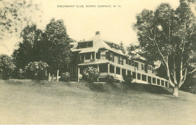
We recently received a donation of the following postcards that help show more of the site when it was the Birchmont Club (click on images to enlarge them).
At this point the estate included tennis courts...
What the post cards and photos above do not show are the magnificent views from the hill, which had been discovered by an earlier generation of painters and photographers. However, before we look at some of their art, let's look at some maps to orient ourselves.
The 1892 map above is from the same atlas that has the print of Tucker's summer home. It links his house to other sites we will explore in this and other blogs including his next door neighbor, the home and studio of Benjamin Champney.
The NH Stone Wall Mapper program here offers combination of both modern and historic maps. On the one hand lidar lidar, lasers on the other hand layer old quad maps 1896, 1942 and 1945. If have any questions about how to navigate through this just contact us.
Here is a fairly standard satellite view of the north half of Sunset Hill.
The image is bisected by the railroad tracks and just to the right of that busy Route 16/302.
On the right half of the image you can see the curving entrance driveway leading to the red roofs of the Red Jacket Inn and it's blue pool.
On the left side of the image you can see farmed fields, woodlots and the Saco River with a wide beach.
Below is a view of the same coordinates with the lidar layer selected. Lidar stands for (laser imaging, detection and ranging) and is a remote sensing method in which a pulsed laser measures the relative distance of the surface of the ground and the computer generates an image as if the buildings and trees have been removed showing the shape of the landscape.
You can also apply layers of quad maps this one blow from 1896.
This one below from 1942 you can see more roads and buildings being added
Now to the vista the views from the ground to the mountain peaks along the horizon.
This small hill is home to an astounding number of White Mountain paintings. It was the center of many viewpoints looking in many directions.
The view to the northwest is featured on the cover of our main history of Conway and while unsigned, the artist was probably a student of Champney.
In previous blogs we examined different versions of a single view of Mount Washington from Sunset Hill starting with an enlargement of a print at the library.
I mentioned then that the scene had been enlarged for easy study and can be found on the stair hall leading down to the Henney History Room at the Conway Public Library. The print was made from the painting below by Kensett. The painting was purchased by the American Art Union and made into an engraving by James Smillie, and distributed to 13,000 Art Union subscribers throughout the country.
The print at the library above was based on this painting Mount Washington from the Valley of Conway by John Frederick Kensett, below. It is now in the collection of the Wellesley College Museum. You can read about it here on the White Mountain Art website.
Compare the painting with the photo below which I took last autumn, hoped leaves off the trees, but still too many evergreens to capture the scene as it was.
Although if you could cut some of those trees and add a few sheep you would recreate the view Kensett saw.
Today, you can’t see this view most of the year due to the trees that have grown up since the days when this was a farming landscape and the fields were more open.
Another Kensett painting shows the view in summer (no summit snow) here.
Thanks to the hard work of webmasters and art collectors John Henderson and Roger Belson, the White Mountain Art website includes twenty-one more painting of this same view (not counting the four we have already examined).
Many of them have "from Sunset Hill, North Conway" in their title. You can also confirm the id by the summit profiles of Mount Washington usually at or near the center and pyramidal sharp point of Adams on the right.
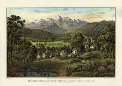
Currier and Ives published their version of the painting around 1860. Later their image was used as inspiration for wall decoration in the Currier and Ives room at the Eastern Slope Inn.
You can read more about the Currier and Ives here.
Other examples of Tucker's involvement in the arts include this sculpture below which you can read about here.
According to the pamphlet about his own marble bust (on page 25 here) he also understood and appreciated the social and cultural contexts of art. "He loved the good, the true, and the beautiful."
"Once in my library as he stood admiring some rugs I had shown him, he said, "But, ah! doctor, think of the condition of the life of those in the Orient who made them, "of fingers weary and worn, of eyelids heavy and red," and how little those poor people received of what you have paid for them." And there was that twinkle in his eyes and expression of his face that spoke volumes."
An interesting sentiment for a successful capitalist. This sheet music was dedicated to him in 1895.


Great post! Thanks, Bob. Very interesting.
ReplyDelete