Wednesday, July 29, 2020
Pond Water Ice Cream
With the recent heat waves, we have all been searching for a way to "chill out." I have been finding refreshment by examining old maps to savor a favorite taste of summer (mine is blueberry basil flavor). It is one of the ways I have been celebrating National Ice Cream Month.
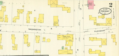
But what does this have to do with pond water as my blog title suggests? Well, take a look at the image above from the 1908 Sanborn insurance map from the collection of the Conway Public Library's Henney History Room (click on images to enlarge them). Can you find the three ice houses on the map that were once within a short distance from the library? (Hint: all are small wood frame buildings - indicated by the yellow color code - and located away from the street behind the main buildings. Two are associated with dwellings and one with a hotel).
The Conway Public Library is easy to find by its red color, representing brick. However, if you look closely at the library you will also find part of it with blue and the yellow. To find out why, see our previous blog here.
We will examine more on how these traditional ice houses worked and historic ways to make ice cream later, but where did the ice come from? To find the potential likely source of the ice for these ice houses let's go down the street and around a couple corners. Unfortunately, the 1908 map does not show this area, so let's jump ahead in time see it on our 1923 Sanborn insurance map.
The areas covered on the map are numbered and colored coded on the index page.The 1923 Sanborn map shows two ice houses on the shore of Pequawket Pond (note north is towards the left on this view of the map).
Early next month, the Upper Saco Valley Land Trust will present a couple related programs exploring Pequawket Pond. For more information see the links here and here.
Here is a detail of the image above.
... and even closer detail.
Notice the grey shading around the outside of the ice house on the right.
According to the "Key" printed on the map, gray represents "iron" indicating that the building was sheathed in "iron" or tin.
In another version of the map, a "paste over" shows that the two ice houses were replaced or merged to become one larger one with conveyors suggesting that the operation was modernized.
Detail
Even closer detail.
Even though modernized, much of the industry continued to use simple, traditional tools. These techniques are presented each winter at numerous locations throughout New England, including at the Remick Farm Museum in Tamworth. The traditional ice harvesting process was also featured in the beginning of the first movie Frozen.
In the library's 1929 version of the Sanborn maps an ice cream mfg. (manufactory) shows up not far from the Conway Public Library in 1929.
Here you can see that building in the bottom left corner of this detail of the map and its relation to the "four corners" intersection of this detail of the map.
Here is a "zoomed" out version.
For more information on your local history contact us at the Conway Public Library's Henney History Room.
Subscribe to:
Post Comments (Atom)


No comments:
Post a Comment